NIRA Dynamics and Audi is taking another step toward safer and more intelligent mobility. The premium carmaker is using high-precision swarm data to improve its car-to-X service known as Local Hazard Information.
The updated version uses a car-to-cloud application based on an innovative technology that detects the tiniest changes in road surface adhesion, uploads data to the cloud for processing, and warns upcoming drivers of road ice or other slippery conditions in near real time. The data comes from NIRA’s recently launched product, Road Surface Alerts.
Since 2017, Audi cars have been able to warn each other about accidents, broken down vehicles, traffic jams, road ice, or limited visibility. NIRA and Audi are now taking the next step in vehicle safety by improving the service with high-precision cloud data to make alerts even faster and more precise. Audi is the first car manufacturer to utilize the Road Surface Alerts technology from NIRA Dynamics AB for this purpose. The two companies adapted this solution as a basis to develop enhanced hazard alerts, together with the Car.Software organization and HERE Technologies.
“This is a huge milestone for NIRA as a company. Many years of hard work has finally resulted in a service that we think can benefit the entire automotive industry and the society as a whole. The cooperation with Audi is extremely important as we have gained a lot of insights on the demands for coverage and data quality. Decreasing the number of accidents is the foundation of what we want to achieve, and this service will help us achieve that.” says Johan Hägg, Head of Marketing & Communication.
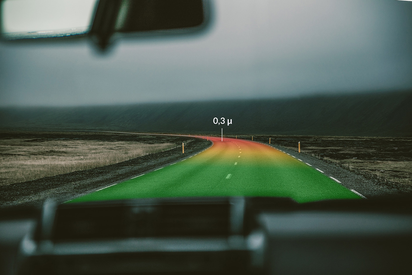
Within the car, the system can estimate the coefficient of friction between the tires and the road surface based on wheel slip. To calculate this, it uses chassis signals, such as wheel speed and acceleration values. It is active in normal driving situations and not only during extreme situations when chassis control systems intervene. The sensor data is anonymized, both in the car itself and when transmitted to the cloud. Aggregated data from many vehicles is then combined with metadata, such as current and historical weather information, and then transmitted by NIRA cloud to service provider HERE Technologies. When integrated with the HERE location platform, the combined data intelligence represents the road network as a precise three-dimensional model.
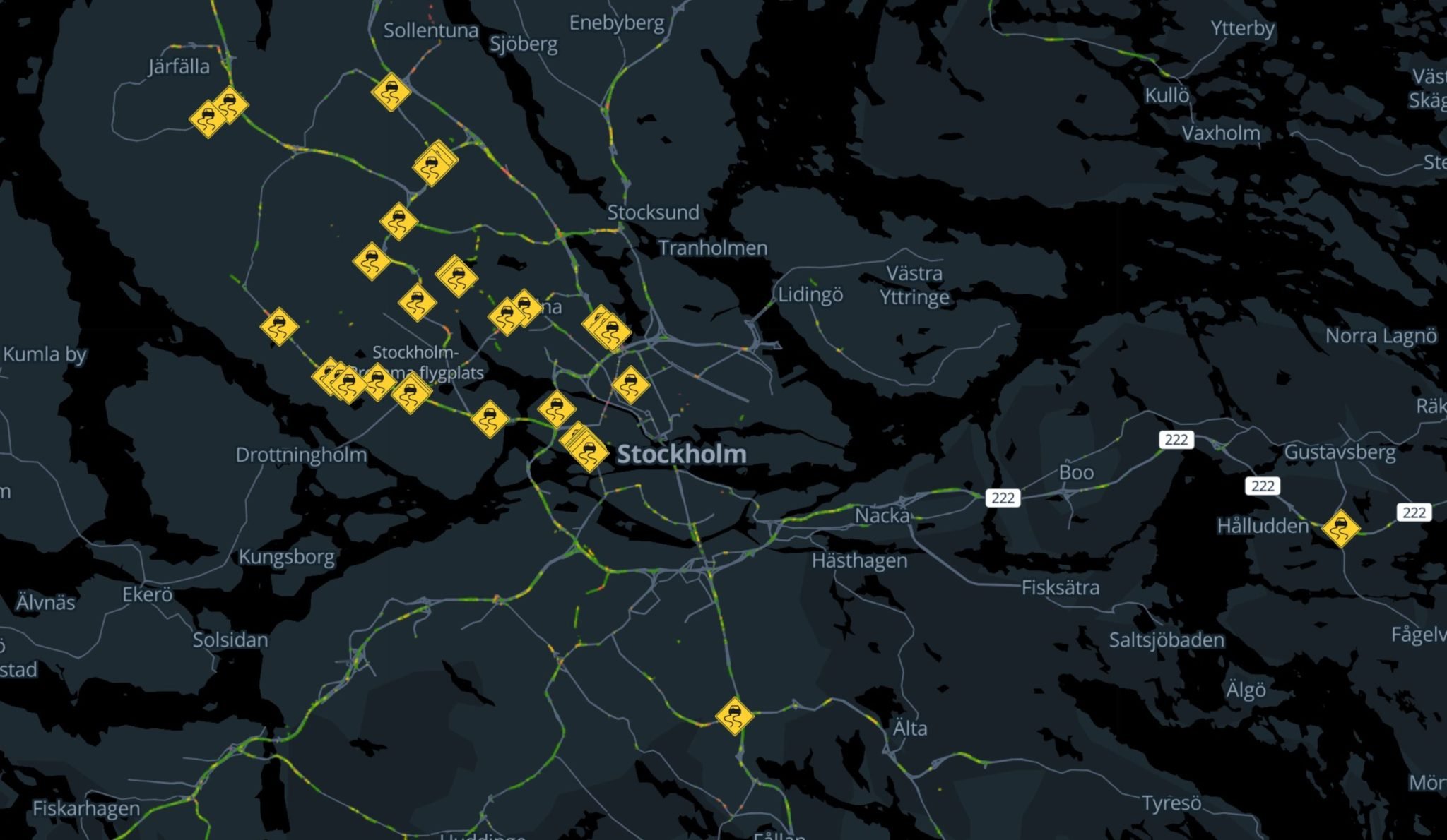
Coming back to the vehicle, HERE servers send the warning information to those cars that are in, or are heading toward areas with poor conditions. The driver sees a warning in the Audi virtual cockpit or on the optional head-up display and can act accordingly.
Number of vehicles involved is a key success factor
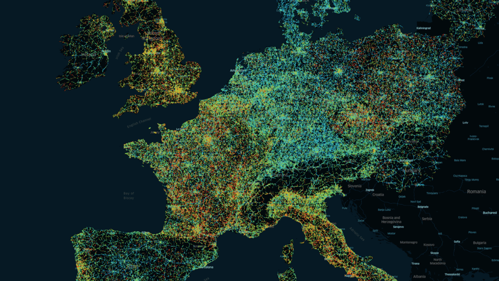
The greater the number of vehicles that deliver data, the better the system can learn, analyze, and create maps, and thereby inform or warn drivers depending on the situation. This is the basic principle of swarm data and swarm intelligence. In 2021, more than 1.7 million vehicles from the Volkswagen Group in Europe will contribute data to this improved hazard information service, and this will increase to more than 3 million in 2022, creating a significant competitive advantage. The service is available in new models from Audi, Volkswagen, SEAT, Škoda, Porsche, Bentley, and Lamborghini.
This is the first customer application in which vehicle data is applied to this type of cutting-edge data analysis. “This project for improved hazard information is a good example of the high potential of cross-brand software development. Together with other Group brands and our strategic partners, we were able to develop a digital service within a few months, while making use of our own software skills and economies of scale,” says Thomas Müller, Head of Advanced Driving Assistance Systems ADAS & Automated Driving AD at the Car.Software organization. The new and improved local hazard information service is just the beginning; we see wide-ranging potential for the future. Utilizing current friction coefficient maps based on this data pool, municipalities can optimize snow clearing services in real time and also reduce environmental impact by using less road salt. Driver assistance systems can ‘pre-learn’ and adjust to the condition of the road with even greater precision, and route guidance in the navigation system can take road conditions into account in order to provide a more accurate calculation of the expected time of arrival. Inside the car, control of wheel slip can enable development of new tire maintenance services, for example, detecting the level of wear as well as tire performance levels.